2026 Construction Updates
Elgin County is investing in roads and infrastructure to keep people and goods moving safely and efficiently.
This page shares current and upcoming construction updates, potential traffic impacts, and what to expect as work moves forward across the County. Together, we are driving Elgin forward.
Below is a map of all projects. Zoom in or click on any red line or dot for more details. Full project descriptions are listed below the map in alphabetical order.
For All Projects
What to Expect
Drivers are encouraged to plan ahead, use alternate routes when possible, slow down in work zones, and watch for posted signage. Residents can sign up for construction updates to stay informed as projects progress.
How Will I Know When These Projects Will Occur
All construction projects below are scheduled for 2026. Project timelines, notices, and traffic impacts will be shared through this engagement site, our Elgin County Facebook page, and our Municipal 511 website.
What We Can and Cannot Control
The County coordinates closely with contractors to minimize disruption where possible. Some factors, such as weather conditions, are beyond our control and may affect construction schedules. We appreciate your patience and will provide timely updates when changes occur.
Frequently Asked Questions (FAQs) can be found here.
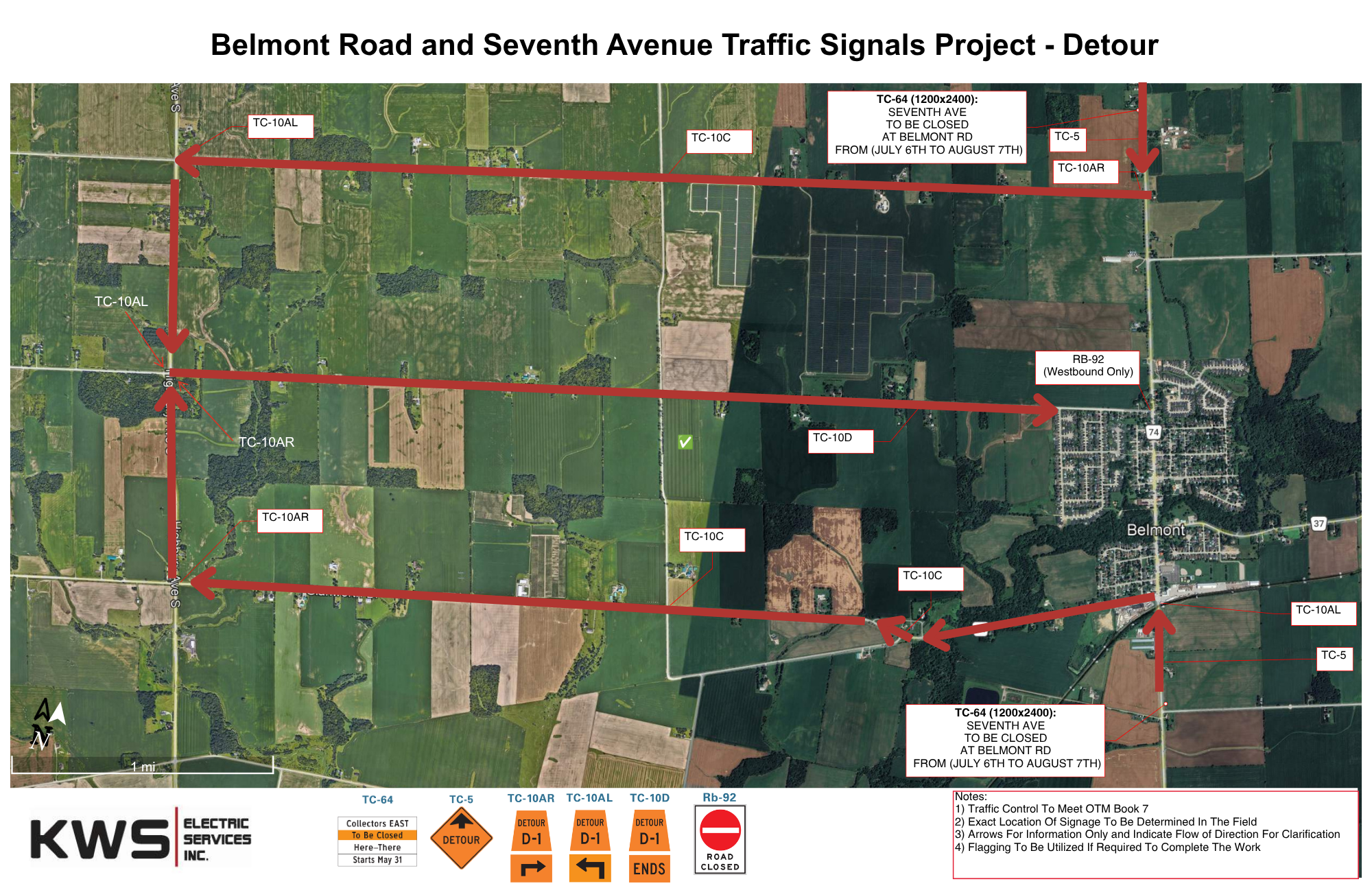
Belmont Road and Seventh Avenue Traffic Signals Project
Location: Belmont Road at Seventh Avenue
What’s Happening
New traffic signals will be installed at the intersection with turning lanes and crosswalks to improve vehicle and pedestrian movement through the intersection.
Traffic Impacts
Expect single-lane closures during construction hours with short delays. Detours and advance notice will be provided if full closures are required. See detour for closure of Seventh Ave from July 6 - 31st:
Why This Work Is Needed
The new traffic signals will improve safety for drivers, pedestrians, and students near the nearby school, and support smoother, more efficient traffic flow through this growing intersection.
Calton Line Rehabilitation Project
Location: Calton Line from Springfield Road to Richmond Road
What’s Happening
This project rehabilitates the roadway and includes pavement removal, base repairs, new asphalt, drainage improvements, roadside shouldering (adding gravel or asphalt along the road edge), and repainting road lines after paving.
Traffic Impacts
Expect single-lane closures during construction hours with short delays. Detours and advance notice will be provided if full closures are required.
Why This Work Is Needed
Calton Line is an important regional route serving both local and regional traffic. Rehabilitation is required to address aging infrastructure, improve safety, and maintain long-term reliability.
✅ COMPLETED - Dalewood Road and Ron McNeil Line Traffic Signals Project
Location: Dalewood Road at Ron McNeil Line
What’s Happening
New traffic signals were installed in December 2025. To further support this project, additional turning lanes will be added to ensure the intersection continues to function to an acceptable level of service into the future.
Traffic Impacts
Expect single-lane closures during construction hours with short delays. Detours and advance notice will be provided if full closures are required.
Why This Work Is Needed
This intersection is a major County route use daily by residents, businesses, and visitors. Traffic signals improve intersection safety, traffic flow, and visibility for all road users.
Eden Bridge Rehabilitation Project
Location: Eden Bridge on Eden Line near Sandytown Road
What’s Happening
Eden Bridge is undergoing a comprehensive rehabilitation to modernize and strengthen the existing structure. This work includes the installation of new structural steel components, replacement of bridge bearings, and upgrades to key elements that support the bridge deck and overall stability.
Traffic Impacts
To complete the rehabilitation as efficiently as possible, the bridge will be fully closed for the duration of the project. Official detour routes will be clearly posted in advance of construction to help motorists plan accordingly.
Why This Work Is Needed
Over time, normal wear, weather exposure, and increasing traffic demands place stress on bridge components. Rehabilitation ensures the bridge remains safe and functional while extending its service life.
Fulton Bridge Removal Study and Removal Project
Location: Fulton Bridge on Fulton Bridge Line at Middle River Road on Kettle Creek
What’s Happening
As recommended in the Transportation Master Plan (which sets the County’s long-term transportation vision) and the Asset Management Plan ( which outlines asset conditions, sets service goals, and guides long-term investments for sustainable, efficient service delivery) the County is undertaking a study to assess the bridge and plan for its removal. Removal work will proceed following the study.
Traffic Impacts
The bridge will remain open until the study determines a timeline for removal. The bridge will be closed when removal work begins. Closure notices and detours will be posted in advance on the Municipal 511 webpage.
Why This Work Is Needed
The bridge has reached the end of its service life. Removing it will reduce ongoing maintenance costs, with alternative routes recommended to maintain safe and reliable travel.
Glen Erie Line Slope Stabilization Project
This project has a dedicated project page that outlines the locations, timing, traffic impacts and how it will improve the infrastructure and flow of all modes of transportation once complete. Click here to view this page.
Imperial Road and John Wise Line Intersection Control Beacon Project
Location: Imperial Road at John Wise Line
What’s Happening
A new intersection control beacon will be installed. It will flash yellow for drivers on Imperial Road to indicate that vehicles on the other road must stop, and red for drivers on John Wise Line to indicate a full stop is required.
Traffic Impacts
Minimal traffic disruptions are expected, land closures are not anticipated. Please drive with caution, crews will be working overhead.
Why This Work Is Needed
These beacons will improve driver awareness of the stop sign ahead and other potential conflict points at the intersection.
Iona Road Rehabilitation Project
Location: Iona Road from Highway 401 to the Thames River
What’s Happening
This project rehabilitates the roadway and includes pavement removal, base repairs, new asphalt, drainage improvements, roadside shouldering (adding gravel or asphalt along the road edge), and repainting road lines after paving.
Traffic Impacts
Expect single-lane closures during construction hours with short delays. Detours and advance notice will be provided if full closures are required.
Why This Work Is Needed
Iona Road connects key regional routes and supports local traffic and goods movement. Rehabilitation is required to address aging infrastructure, improve safety, and maintain long-term reliability.
Jamestown Bridge Removal Study and Removal Project
Location: Jamestown Bridge on Jamestown Line over Catfish Creek
What’s Happening
As recommended in the Transportation Master Plan (which sets the County’s long-term transportation vision) and the Asset Management Plan ( which outlines asset conditions, sets service goals, and guides long-term investments for sustainable, efficient service delivery) the County is undertaking a study to assess the bridge and plan for its removal. Removal work will proceed following the study.
Traffic Impacts
The bridge will remain open until the study determines a timeline for removal. The bridge will be closed when removal work begins. Closure notices and detours will be posted in advance on the Municipal 511 webpage.
Why This Work Is Needed
The bridge has reached the end of its service life. Removing it will reduce ongoing maintenance costs, with alternative routes recommended to maintain safe and reliable travel.
Putnam Road Reconstruction Project
Location: Putnam Road from Avon Drive to Lyons Line
What’s Happening
Malahide Township will be replacing the Avon Drain located beneath Putnam Road. Once the drainage work is complete, Elgin County will reconstruct the road surface from Avon Drive to the south settlement limits. Road reconstruction will include removal of the existing asphalt, base repairs as needed, placement of new asphalt to restore the roadway, roadside shouldering (adding gravel or asphalt along the road edge), and repainting road lines after paving.
Why This Work Is Needed
The Avon Drain runs directly beneath Putnam Road and requires replacement to maintain proper drainage and protect surrounding properties. Once the drain work is completed, the road must be reconstructed to restore driving conditions and ensure long term durability.
Ron McNeil Line Rehabilitation Project
Location: Ron McNeil Line from Imperial Road to Springfield Road
What’s Happening
This project rehabilitates the roadway and includes pavement removal, base repairs, new asphalt, drainage improvements, roadside shouldering (adding gravel or asphalt along the road edge), and repainting road lines after paving.
Traffic Impacts
Expect single-lane closures during construction hours with short delays. Detours and advance notice will be provided if full closures are required.
Why This Work Is Needed
Ron McNeil Line serves as a key connector for regional routes and supports the movement of local traffic and goods. Rehabilitation is required to address aging infrastructure, improve safety, and maintain long-term reliability.
Talbot Line Resurfacing Project
Location: Talbot Line from Macpherson Road to Iona Road in West Elgin and Dutton Dunwich
What’s Happening
The roadway will be resurfaced with a new layer of asphalt placed over the existing pavement. The project also includes roadside shouldering (adding gravel or asphalt along the edge of the road to support the pavement) and repainting of road lines once paving is complete.
Traffic Impacts
Single lane closures will be in place, with roughly 2 km of roadway completed per day. Short delays should be expected through active work zones.
Why This Work Is Needed
Talbot Line is a major County route used daily by residents, businesses, and visitors. Resurfacing improves driving conditions, reduces water-related damage, and extends the life of the roadway. It is also a faster and less disruptive type of road work and supports Talbot Line’s role as an emergency detour route when Highway 401 is closed.
Union Road Rehabilitation Project
Location: Union Road from Rose Ave to Third Line
What’s Happening
This project rehabilitates the roadway and includes pavement removal, base repairs, new asphalt, drainage improvements, roadside shouldering (adding gravel or asphalt along the road edge), and repainting road lines after paving.
Traffic Impacts
Expect single-lane closures during construction hours with short delays. Detours and advance notice will be provided if full closures are required.
Why This Work Is Needed
Union Road serves local residents and agricultural traffic. Rehabilitation improves safety, addresses deterioration, and extends the service life of the road.
Village of Fingal Reconstruction Project
A dedicated project webpage outlines locations, timing, traffic impacts, and planned improvements to the roadway once complete. Click here to view this page.
Ministry of Transportation (MTO) - Highway 3 Talbotville Bypass Project
The MTO is leading the Highway 3 Talbotville Bypass Project in Elgin County. This project began in the summer of 2025 and is expected to be completed by the winter of 2027. The work includes:
- A new Highway 3 alignment bypassing Talbotville
- Widening Highway 4 from two to four lanes between Clinton Line and the new bypass
- A new roundabout at Highway 4 and the Talbotville Bypass
- A new interchange at Highway 3 and Ron McNeil Line / Wonderland Road
- A new grade separated CN Railway crossing
- Associated drainage and infrastructure improvements
As this is a provincially led project, residents are encouraged to visit the project website for the most up to date information, staging details, and contact information:
Who's Listening
-
Manager of Roads and Asset Management
Email aparker@elgin.ca